In the vast, semi-arid expanse of Tsavo East National Park, a colossal stone sentinel, Mudanda Rock, dictates the rhythm of life, not merely by its sheer physical presence, but through complex hydrogeological dynamics that transform it into an indispensable natural water tower.
 This 1.6-kilometer-long inselberg is more than a striking landmark; it is a critical life-support system for the park's diverse fauna. This article dissects the scientific mechanisms that enable Mudanda Rock to capture, channel, and store precious water, exploring how its unique geology interacts with the region's climate to create a life-sustaining resource.
Geology of The Foundation Of Mudanda Rocks Water Collection
The capacity of Mudanda Rocks to act as a water tower begins deep within its geological structure. The rock is predominantly composed of Precambrian metamorphic rocks, mainly gneisses and schists.
These ancient, crystalline formations, forged under intense heat and pressure millions of years ago, are characterized by their very low porosity and permeability. This means that water does not readily seep into or pass through the main rock mass.
Unlike porous sedimentary rocks that might absorb a significant portion of rainfall, Mudanda’s dense, impermeable surface acts as an efficient catchment, promoting surface runoff rather than absorption. This fundamental characteristic is the primary reason it can harvest substantial volumes of water.
Furthermore, the sheer scale and morphology of Mudanda Rock optimize this runoff efficiency. Its extensive 1.6-kilometer length and considerable width provide a vast surface area for rainwater interception.
The slopes of the inselberg might appear gentle to the casual observer but they are sufficiently inclined to channel water downwards effectively. This combination of impermeability, large surface area, and conducive gradient ensures that a high percentage of the rain that falls on the rock is directed towards its base, forming the foundation of its water-collecting prowess.
Tsavos Climate and Mudanda Rocks Precipitation
The hydrogeology of Mudanda Rock is intrinsically linked to the climatic patterns of Tsavo East.
The region experiences a bimodal rainfall pattern, with the "long rains" typically occurring from March to May and the "short rains" from October to December. These two periods provide the primary water input for the entire ecosystem, and Mudanda Rock is perfectly positioned to maximize this seasonal bounty.
The intensity and duration of these rainfall events significantly impact the volume of water captured. Tsavo's rains can often be characterized by heavy, convective downpours of relatively short duration, and Mudanda's vast, exposed surface excels at intercepting this direct precipitation.
A key factor in Mudanda Rock’s water harvesting efficiency is the minimal loss of water at the initial point of capture. The main rock surface is largely devoid of significant soil cover or dense vegetative canopy.
This barren nature means that very little rainwater is lost to processes like soil absorption or evapotranspiration directly from the rock surface itself during a rain event. Almost all the water that falls onto it is immediately available to become runoff, maximizing the yield for the waterhole at its base.
Runoff and Basal Waterhole Formation at Mudanda Rock
Once rainwater makes contact with Mudanda Rock's surface, a fascinating hydrological journey begins.
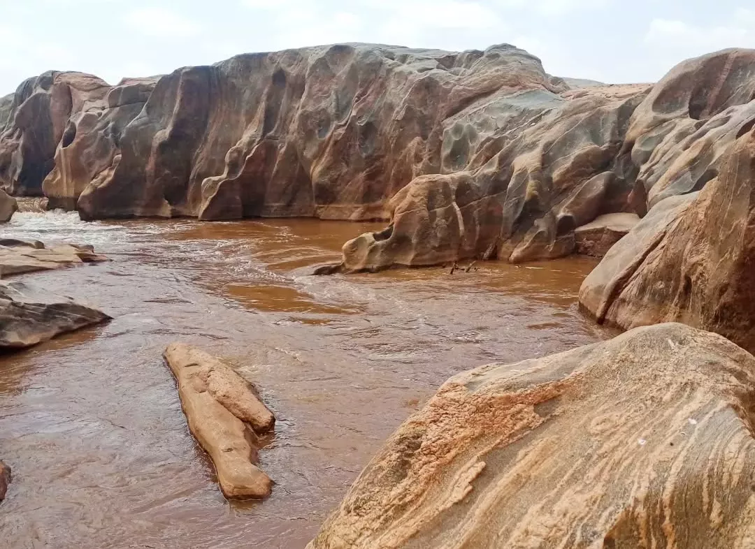
During significant rain events, water flows over the expansive rock face primarily as "sheet wash"—a broad, thin layer of water moving down the gradient. However, the rock's surface is not perfectly smooth; it is characterized by natural fissures, solution pans, shallow depressions, exfoliation sheets, and undulations.
These features act as natural channels, intercepting the sheet wash and guiding the water flow into more concentrated streams. This efficient channeling system, developed over geological timescales, directs the collected water with remarkable precision towards specific low-lying areas at the rock’s perimeter, particularly its eastern base.
At this eastern base, the local topography, likely a combination of the underlying bedrock structure and the deposition of finer sediments carried by the runoff, creates a natural depression. This basin acts as a natural reservoir or dam, impounding the substantial volumes of water channeled from the rock's surface.
This is the renowned Mudanda Rock waterhole, a critical feature that can hold water for extended periods. The actual volume and surface area of this waterhole fluctuate dramatically, expanding significantly after heavy rains and gradually receding during the intervening dry spells, a direct reflection of the hydrogeological inputs and outputs.
Water Persistence Factors Influencing Mudanda Rocks Water Supply
The value of Mudanda Rock as a water source is not just in its ability to collect water, but also in its capacity to retain it, particularly into the dry seasons.
Several factors contribute to the persistence of its water supply.
Tsavo East is a semi-arid environment and experiences high ambient temperatures and significant solar radiation throughout much of the year. These conditions lead to high potential evaporation rates from any exposed water surface.
The surface area of the Mudanda Rock waterhole directly influences the amount of water lost to evaporation; however, the natural dam often has deeper sections where water is more protected and persists longer.
Crucially, the geology of the waterhole's basin itself plays a vital role in minimizing seepage losses. If the base were highly porous, the collected water would quickly percolate into the ground. However, the fine sediments, such as clays, washed down from the rock and deposited in the basin, along with the nature of the underlying bedrock, likely create a relatively impermeable seal.
This low seepage rate is fundamental to the waterhole's ability to hold water for many weeks or even months after the rains have ceased, making it a far more reliable source than shallower, more permeable seasonal pans.
The primary benefit is surface water, but it's also plausible that some slow infiltration around the waterhole's periphery contributes to localized shallow groundwater recharge, which in turn supports the greener, more resilient vegetation often observed immediately around such persistent water sources in dry landscapes.
Mudanda Rocks Hydrogeological Significance for Tsavo Easts Ecosystem
The intricate hydrogeological processes at Mudanda Rock culminate in a feature of immense ecological importance for Tsavo East National Park.
Its ability to capture and, critically, retain water makes it an undisputed lifeline, particularly during the harsh dry periods when other water sources become scarce or disappear entirely.
This reliability directly supports the large populations of elephants, buffalo, zebra, giraffes, and numerous other water-dependent wildlife species that characterize Tsavo. The concentration of animals around this predictable resource also influences predator distribution and behavior.
Beyond direct water provision for fauna, the sustained moisture around the Mudanda Rock waterhole likely influences the local vegetation composition and structure.
A narrow, more verdant strip of riparian-like vegetation may thrive along the waterhole’s edge and drainage lines, offering distinct microhabitats for smaller fauna, insects, and specialized plant communities that contrast with the drier, more open plains further away.
In a broader context, Mudanda Rock serves as a classic case study in inselberg hydrogeology. It perfectly exemplifies how these isolated geological formations, through their unique physical and hydrological characteristics, can become critical hydro-ecological nodes within savanna ecosystems.
The rock's water-concentrating function is a natural marvel of landscape-scale resource partitioning, ensuring that life can persist even when the surrounding environment is under significant water stress. Its presence shapes animal movement, foraging strategies, and the overall ecological fabric of this part of Tsavo East.
To witness the profound ecological impact driven by Mudanda Rock's unique hydrogeology and to see the wildlife that depends on it, consider planning your visit to Tsavo East.
Learn more about accessing this incredible natural feature by visiting https://kenyapeaks.com/tsavo-east-national-park/mudanda-rock.